
Walk Length and Type
A linear walk of approximately 4.1miles/6.6kms
Description of Walk
This linear walk as part of the Radstock Ring starts opposite the Hope and Anchor pub in Midford, and roughly follows the Cam Brook with a deviation into Combe Hay before finishing at Dunkerton.
Description of Area
Midford sits on the south western edge of Cotswold Area of Outstanding Natural Beauty. The Cam and Wellow Brooks join at Midford to form the Midford Brook and onwards to the River Avon. You will be walking an area of industrial heritage where remains of the Somersetshire Coal Canal surface in parts and the old railway line of the Somerset & Dorset Railway spasmodically pops up. The Titfield Thunderbolt (1950's comedy film) used many sections of Camerton and Limpley Stoke Railway line which served the Somerset Coal field and crossed the Somerset & Dorset line at Midford. Engine Wood on the east side of Combe Hay provides leafy shade and natural habitat for a variety of birds. Combe Hay is an ancient village, south of Bath, in the shelter of the Cam Valley. There is a handsome Georgian rectory and a Manor House with adjacent church. Fullers Earth was excavated from the hills to the north of Combe Hay. Farmland links the village of Combe Hay to Dunkerton where the busy A367, Bath to Exeter road, provides links to public transport, but not before you have walked the banks of the Cam Brook.
The Basics
Map
Download route:
The Route
[1] Cross the main Midford Road away from the Hope & Anchor Inn, watching out for traffic and you now join the Limestone Link path as far as Dunkerton Church. Directly opposite the inn, take the footpath down with a garden on the left, which goes under the old Somerset and Dorset Railway bridge.
Go through a wooden kissing gate. The path follows the old canal bank. The stone bridge on the left led to a canal basin. Go through a further wooden kissing gate and bear left past a picturesque but unsafe stone bridge to another wooden kissing gate.
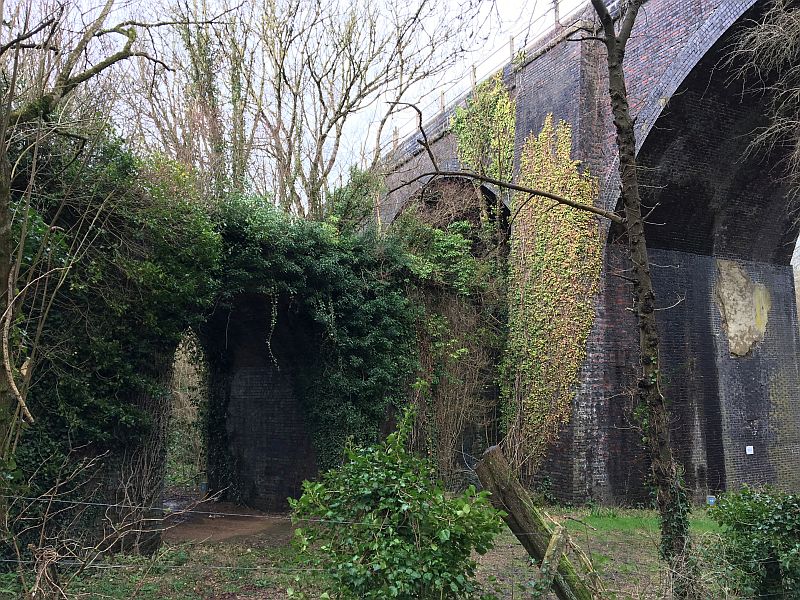
[2] Descend to the left through a wet and muddy area, then bear right and go under a railway arch. The acoustics here amplify and misdirect the sound of the stream.
Bear right up the slope (NOT into the field by the stream),and then through a wooden kissing gate on the left some 50 m further on, and go into the field. Walk through open fields along the former towpath with the contour of old canal bed to the right, to a metal kissing gate.
[3] Pass through the metal kissing gate and continue along the old canal. After another field go up some steps to a metal kissing gate in the right hand corner of field.
[4] Go through the metal kissing gate and come onto a track. Turn right and then immediately left through a metal pedestrian gate and down through the wood. The canal bed is now on the left hand side under heavy vegetation. This section can be muddy. Follow the path past a long narrow field. This was the site of two locks on the canal. Upon reaching the fence at the end of the field, bear right up to a wooden kissing gate which opens onto a road, opposite another railway arch.

[5] Cross the road and go under an old railway arch. This is the bottom of the old Combe Hay flight of canal locks, which are quite well preserved, with most of the lock chambers still clearly visible. There is an information board on the right under the arch.Cross the stile and head straight on along the path with a fence on the right and the flight of canal locks on the left. At the wooden kissing gate above a wooden footbridge to the left, the Radstock Ring path goes straight on. In approximately 50 m, turn left at the waymark sign.
[6] Ford the stream, then immediately turn left again at the second waymark sign, and climb up through a meadow and then through a short stretch of woodland to a wooden kissing gate at the top. Go through the wooden kissing gate, and continue upwards across a second meadow to a further wooden kissing gate at top of the field. Go up the steps and turn left down a track.
[7] Proceed down the track, passing Rowley Farm (ignoring side tracks) to the Midford to Combe Hay road.

[8] Turn right at the road and go towards Combe Hay, passing the Wheatsheaf pub on the right. Walk through the village, bearing left at the fork in the road, go uphill past the church and manor house, then past the old schoolhouse on the right. Continue past the houses and look on your left for a wooden pedestrian gate in the stone wall (footpath sign).
[9] The path descends a steep bank through woodland. Near the bottom, the path forks. Bear right at the fork, then through a wooden kissing gate into a field. Bear half right ahead to the far corner of large field, gradually descending towards the stream on the left. Go through a metal kissing gate to the road.
[10] Turn left and then immediately right through a kissing gate into the field. The path goes slightly left to the bank of the Cam Brook. Walk along the field boundaries with the stream on the left (the stream is mostly hidden by dense woodland), crossing 2 gated wooden footbridges. When the main road (A367) comes into view in front of you, do NOT bear right to the gate that comes into view, but go straight on, up the flight of stone steps and over a stone stile onto this road, at Dunkerton Bridge.
This is a busy main road with fast-moving traffic, so proceed with caution.
[11] There are bus stops for buses to Bath and Wells about 100m up the hill to your right, and a large parking layby 200m beyond that. An alternative layby can be found a similar distance up the hill to the left.